


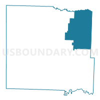
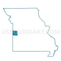
Ballard Voting District, Bates County, Missouri
About
Outline

Summary
| Unique Area Identifier | 607091 |
| Name | Ballard Voting District |
| County | Bates County |
| State | Missouri |
| Area (square miles) | 97.08 |
| Land Area (square miles) | 96.76 |
| Water Area (square miles) | 0.32 |
| % of Land Area | 99.67 |
| % of Water Area | 0.33 |
| Latitude of the Internal Point | 38.35339110 |
| Longtitude of the Internal Point | -94.13741700 |
Maps

Graphs
Select a template below for downloading or customizing gragh for Ballard Voting District, Bates County, Missouri


Neighbors
Neighoring Voting District (by Name) Neighboring Voting District on the Map
- Adrian South Voting District, Bates County, MO
- Bearcreek / Deepwater Voting District, Henry County, MO
- Butler No. 1 Voting District, Bates County, MO
- Davis / Walker Voting District, Henry County, MO
- Hudson Voting District, Bates County, MO
- No. 1 - Sherman Voting District, Cass County, MO
- No. 2 - Dayton Voting District, Cass County, MO
- White Oak Voting District, Henry County, MO
Top 10 Neighboring County Subdivision (by Population) Neighboring County Subdivision on the Map
- Dayton township, Cass County, MO (1,071)
- Sherman township, Cass County, MO (816)
- White Oak township, Henry County, MO (758)
- Deepwater township, Henry County, MO (573)
- Spruce township, Bates County, MO (330)
- Summit township, Bates County, MO (312)
- Grand River township, Bates County, MO (312)
- Deepwater township, Bates County, MO (307)
- Shawnee township, Bates County, MO (271)
- Mingo township, Bates County, MO (237)
Top 10 Neighboring Elementary School District (by Population) Neighboring Elementary School District on the Map
Top 10 Neighboring Unified School District (by Population) Neighboring Unified School District on the Map
- Butler R-V School District, MO (6,338)
- Sherwood Cass R-VIII School District, MO (5,085)
- Adrian County R-III School District, MO (3,923)
- Cass County R-V School District, MO (2,989)
- Ballard R-II School District, MO (867)
- Montrose R-XIV School District, MO (795)
Top 10 Neighboring State Legislative District Lower Chamber (by Population) Neighboring State Legislative District Lower Chamber on the Map
Top 10 Neighboring State Legislative District Upper Chamber (by Population) Neighboring State Legislative District Upper Chamber on the Map
Top 10 Neighboring 111th Congressional District (by Population) Neighboring 111th Congressional District on the Map
Top 10 Neighboring Census Tract (by Population) Neighboring Census Tract on the Map
- Census Tract 701, Bates County, MO (5,248)
- Census Tract 612, Cass County, MO (3,983)
- Census Tract 9503, Henry County, MO (3,286)
- Census Tract 9504, Henry County, MO (3,027)
Top 10 Neighboring 5-Digit ZIP Code Tabulation Area (by Population) Neighboring 5-Digit ZIP Code Tabulation Area on the Map
- 64730, MO (7,109)
- 64747, MO (3,910)
- 64720, MO (3,843)
- 64788, MO (1,415)
- 64770, MO (1,056)
- 64739, MO (997)